19. Region (Condoriri range in the Cordillera Real):


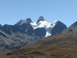
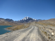
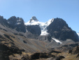
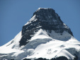
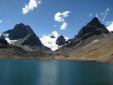
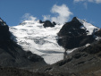
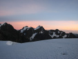
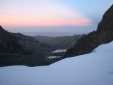
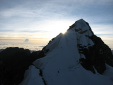
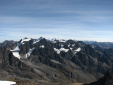
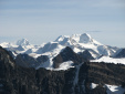
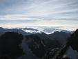
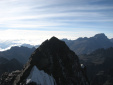
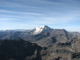
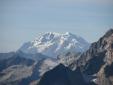
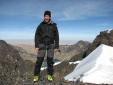
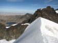
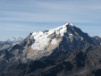
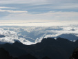
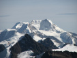
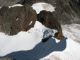
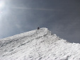
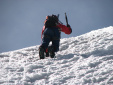
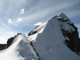
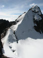
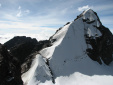
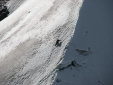
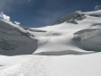
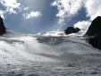
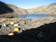
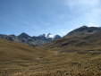
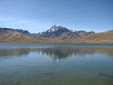
Das Condoriri-Gebiet ist wirklich wunderschön, und gar nicht weit weg von La Paz! Dort hab ich den Pequeno Alpamayo bestiegen, eine Traumtour! Am ersten Tag latscht man nur ans Basecamp am See (Laguna Chiar Khota). Am nächsten Tag gehts dann zuerst den Gletscher rauf bis zum Vorgipfel Tarija (Route siehe Foto 06), wo bei uns langsam die Sonne aufging. Vom Tarija-Gipfel muss man ungefähr 100 Höhenmeter in einen Sattel absteigen, von dem aus der Aufstiegsweg über den scharfen Firn- und Eisgrat bis zum Hauptgipfel startet.

Der Blick von oben ist der Hammer! Man sieht einige schöne 6000er, und Richtung Osten das Regenwald-Tiefland mit den Amazonas-Zuflüssen. Eine super Abschluss-Tour!!
 
The Condoriri area is really gorgeous, and not really far away from La Paz! I climbed the Pequeno Alpamayo there, a stunning tour! The first day, you only have to walk to the basecamp at Chiar Khota lake. The next day, you have to ascend on the glacier until the secondary peak Tarija (see photo 06 for trail), where had breakfast at sunrise. From the Tarija peak, the route descends about 100 height meters into a saddle, where the ascent to the main summit starts, on a sharp ice and firn ridge.

The view from the top is marvellous! You can see a couple of 6000-peaks, and to the east the jungle basin with the Amazon feeders. A great final tour!!


    Image 01 (Condoriri peaks in Cordillera Real)


    Image 02 (Huayna Potosi from Tuni)


    Image 03 (Cabeza del Condor with its wings)


    Image 04 (Cabeza del Condor)


    Image 05 (Basecamp at Laguna Chiar Khota)


    Image 06 (Tarija ascension route of tomorrow)


    Image 07 (Sunrise view from Tarija shoulder)


    Image 08 (View back to basecamp lake)


    Image 09 (Pequeno Alpamayo from Tarija summit)


    Image 10 (Western Cordillera Real from Pequeno Alpamayo summit)


    Image 11 (Zoom to Ancohuma and Chachacomani)


    Image 12 (View east to the jungle lowlands)


    Image 13 (Pico Innominado)


    Image 14 (Huayna Potosi NW-face)


    Image 15 (Zoom to Illimani)


    Image 16 (At the summit, with final part of summit ridge)


    Image 17 (On the central part of the horizon: Lake Titicaca)


    Image 18 (Huayna Potosi and Illimani)


    Image 19 (Zoom to jungle lowlands)


    Image 20 (Zoom to Chachacomani)


    Image 21 (Descent route on ice ridge and ascent to Pico Tarija)


    Image 22 (Guide Agustin descending)


    Image 23 (Descending on the steepest section)


    Image 24 (Ice ridge from col below)


    Image 25 (Pequeno Alpamayo from Pico Tarija)


    Image 26 (Other rope team descending)


    Image 27 (Zoom to other guide descending)


    Image 28 (Final part of the Tarija glacier)


    Image 29 (Tracks on glacier)


    Image 30 (Basecamp at Laguna Chiar Khota)


    Image 31 (Carrier service)


    Image 32 (Condoriri peaks from Laguna Tuni)


    Image 33 (Huayna Potosi at Laguna Tuni)

  • next region

  • back to overview page